Log in
All resources
Create a design
10,904 Free Images of Engraved Maps
copper engraving print
british library
joan blaeu
atlas maior, vol 5 (england) - joan blaeu, 1667 - bl 114.h(star).5
national library of poland
1667 maps
university of texas at arlington
colored engraving on paper
baroque
french-language maps of africa
engravings in the yale center for british art
pierre-charles canot
atlas van der hagen (volume 4)
atlas van der hagen
de praecipvis totivs vniversi vrbibvs, liber secvndvs (1575)
maps of kleve by braun & hogenberg
de praecipvis totivs vniversi vrbibvs, liber secvndvs (1575)
maps of neuss by braun & hogenberg
engravings of hannover
hannover in the 1650s
atlas maior, vol 12 (america) - joan blaeu, 1667 - bl 114.h(star).12
1667 maps
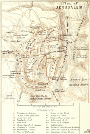
maps from the earth and its inhabitants, vol. ix
old maps of the holy land
latin-language maps
german renaissance
le sénégal. la france dans l'afrique occidentale (1889)
orientalist painting
maps of the dutch east india company - south africa
1747 maps
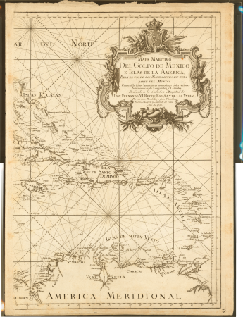
1790s maps of central america
1790s maps of cuba
vrbivm praecipvarvm mvndi theatrvm qvintvm (1617)
maps of los palacios by braun & hogenberg
engravings of the armada tapestries in the rijksmuseum amsterdam
armada tapestries
augustine ryther
oxford castle
media from accademia delle scienze di torino
high renaissance
atlas maior, vol 6 (scotland and ireland) - joan blaeu, 1667 - bl 114.h(star).6
1667 maps
atlas maior, vol 5 (england) - joan blaeu, 1667 - bl 114.h(star).5
17th-century maps of norfolk, england
atlas maior, vol 5 (england) - joan blaeu, 1667 - bl 114.h(star).5
17th-century maps of devon
atlas maior, vol 6 (scotland and ireland) - joan blaeu, 1667 - bl 114.h(star).6
1667 maps
atlas maior, vol 9 (italy) - joan blaeu, 1667 - bl 114.h(star).9
1667 maps of italy
atlas maior, vol 5 (england) - joan blaeu, 1667 - bl 114.h(star).5
17th-century maps of cheshire
atlas maior, vol 5 (england) - joan blaeu, 1667 - bl 114.h(star).5
17th-century maps of kent
atlas maior, vol 5 (england) - joan blaeu, 1667 - bl 114.h(star).5
17th-century maps of cornwall
atlas maior, vol 5 (england) - joan blaeu, 1667 - bl 114.h(star).5
17th-century maps of wiltshire
atlas maior, vol 7 (france i) - joan blaeu, 1667 - bl 114.h(star).7
1667 maps
atlas maior, vol 5 (england) - joan blaeu, 1667 - bl 114.h(star).5
17th-century maps of gloucestershire
atlas maior, vol 5 (england) - joan blaeu, 1667 - bl 114.h(star).5
17th-century maps of hampshire
atlas maior, vol 5 (england) - joan blaeu, 1667 - bl 114.h(star).5
17th-century maps of surrey
atlas maior, vol 11 (asia) - joan blaeu, 1667 - bl 114.h(star).11
1667 maps
atlas maior, vol 5 (england) - joan blaeu, 1667 - bl 114.h(star).5
17th-century maps of suffolk
atlas maior, vol 9 (italy) - joan blaeu, 1667 - bl 114.h(star).9
1667 maps of italy
atlas maior, vol 5 (england) - joan blaeu, 1667 - bl 114.h(star).5
17th-century maps of sussex
atlas maior, vol 5 (england) - joan blaeu, 1667 - bl 114.h(star).5
17th-century maps of dorset
map of bruges by marcus gheeraerts (i)
drawings in the groeningemuseum
19th-century maps of the ottoman empire
maps in the british museum
engravings of topographia braunschweig lüneburg
baroque
engravings of topographia braunschweig lüneburg
baroque
leipzig in the 17th century
baroque
old maps of frankfurt (oder)
old maps of brandenburg
topographia franconiae (merian)
baroque
old maps of saxony
pieter schenk (ii)
atlas van der hagen (volume 4)
atlas van der hagen
maps of the dutch east india company - indonesia
18th-century maps of java
vrbivm praecipvarvm mvndi theatrvm qvintvm (1617)
maps of zell (mosel) by braun & hogenberg
vrbivm praecipvarvm mvndi theatrvm qvintvm (1617)
maps of los palacios by braun & hogenberg
engravings in the yale center for british art
nathaniel whittock
de praecipvis totivs vniversi vrbibvs, liber secvndvs (1575)
maps of neuss by braun & hogenberg
turgot map of paris – derivative files
old maps of île saint-louis
engravings of the armada tapestries in the rijksmuseum amsterdam
armada tapestries
maps by jodocus hondius
maps by petrus bertius
maps by jodocus hondius
maps by petrus bertius
eran laor cartographic collection
jacques-philippe le bas
historical
history
maps by louis brion de la tour
1761 maps of africa
maps by jacques chiquet
1719 maps of africa
a voyage to abyssinia, and travels into the interior of that country, executed under the orders of the british government in the years 1809 & 1810
john outhett
atlas maior, vol 7 (france i) - joan blaeu, 1667 - bl 114.h(star).7
1667 maps
atlas maior, vol 2 (sweden, russia, poland, eastern europe, and greece) - joan blaeu, 1667 - bl 114.h(star).2
17th-century maps of prussia
atlas maior, vol 5 (england) - joan blaeu, 1667 - bl 114.h(star).5
17th-century maps of yorkshire
atlas maior, vol 2 (sweden, russia, poland, eastern europe, and greece) - joan blaeu, 1667 - bl 114.h(star).2
17th-century maps of scandinavia
atlas maior, vol 5 (england) - joan blaeu, 1667 - bl 114.h(star).5
17th-century maps of yorkshire
atlas maior, vol 1 (northern europe, norway, and denmark) - joan blaeu, 1667 - bl 114.h(star).1
17th-century maps of iceland
atlas maior, vol 6 (scotland and ireland) - joan blaeu, 1667 - bl 114.h(star).6
1667 maps
maps of helsingborg by braun & hogenberg
vrbivm praecipvarvm totivs mvndi (1612)
vrbivm praecipvarvm totivs mvndi (1612)
maps of bolsward by braun & hogenberg
maps by jacques chiquet
1719 maps of africa
maps by jacques chiquet
1719 maps of africa
maps by louis brion de la tour
1761 maps of africa
1790s maps of central america
1790s maps of cuba
maps from the earth and its inhabitants, vol. xiv
1870s maps of new zealand
maps from the earth and its inhabitants, vol. vi
maps of the history of russia
maps from the earth and its inhabitants, vol. iv
old maps of the lake district
maps from the earth and its inhabitants, vol. xii
19th-century maps of senegal
maps from the earth and its inhabitants, vol. xi
1870s maps of tunisia
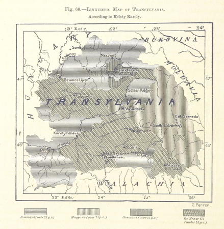
maps from the earth and its inhabitants, vol. iii
linguistic maps of the balkans
maps from the earth and its inhabitants, vol. ix
maps indicating exploration
maps from the earth and its inhabitants, vol. xiii
maps of weather and climate of south africa
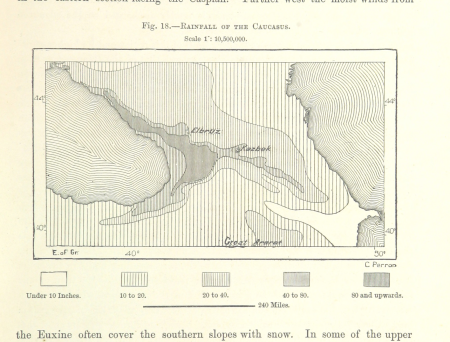
maps from the earth and its inhabitants, vol. vi
maps of weather and climate of asia
maps from the earth and its inhabitants, vol. viii
1870s maps of india
maps from the earth and its inhabitants, vol. xiii
maps of telegraph lines
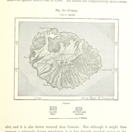
old maps of la gomera
1878 maps of spain
maps from the earth and its inhabitants, vol. xiii
maps indicating exploration
18th-century maps of veneto
1700s maps of slovenia
maps of coimbra by braun & hogenberg
maps by pieter van der aa
juan de la cruz cano y olmedilla
maps by tomas lopez
truscott map of st-petersburg 1753
engraved maps of saint petersburg
maps by thomas kitchin
1780 maps of africa
maps in the staats- und universitätsbibliothek hamburg
1670s maps of hamburg
atlas maior, vol 5 (england) - joan blaeu, 1667 - bl 114.h(star).5
17th-century maps of yorkshire
atlas maior, vol 2 (sweden, russia, poland, eastern europe, and greece) - joan blaeu, 1667 - bl 114.h(star).2
17th-century maps of scandinavia
atlas maior, vol 5 (england) - joan blaeu, 1667 - bl 114.h(star).5
17th-century maps of yorkshire
atlas maior, vol 2 (sweden, russia, poland, eastern europe, and greece) - joan blaeu, 1667 - bl 114.h(star).2
17th-century maps of prussia
cetus (constellation) in art
uranometria
maps from the earth and its inhabitants, vol. ix
old maps of the holy land
19th-century maps of crimea
g. h. swanston
maps of haarlemmerhout
old maps of haarlem
theatri praecipvarvm totivs mvndi vrbivm : liber sextvs (1618)
maps of york by braun & hogenberg
vrbivm praecipvarvm totivs mvndi (1612)
maps of bolsward by braun & hogenberg
merian mainz trier köln
baroque
maps from the earth and its inhabitants, vol. viii
buddhist pilgrimage sites in india
1601 - 1700 of 10,904
Next page
/ 110